Book activities
Webcams
Road info
CARNET_VOYAGE
0
OK
Menu
Ossau Valley
Ski resorts
Artouste resort
Gourette resort
Pyrenees Inspirations
History, heritage & traditions
The legendary mountain passes
Natural sites
Pastoralism
Explore
The must-sees
Discover our 18 villages
Accomodation
Where to sleep?
Hotels
Bed and Breakfast
Campsites, Motor homes
Holidays Villages - Residence
Inns, Refuges
Mountain refuge
Group organisations
Unusual
Estate agencies
Apartments
Our trips
4 season breaks
Winter breaks
Summer breaks
Our top tips
Availability and Booking
Info / Free quote
Holiday rentals
Group
online ticketing
About us
Activities
Tours, Itineraries
Walks and hikes
Trail
Nordic Walking
Terra Aventura
Randoland walks
MTB, Cycling
Mountain Guides
Snowshoes
Artouste Train
Visits and discoveries
Museum areas
Farm & Producer Visits
Lac de Castet Natural Area
Artouste Train
Sports and Leisure
Climbing
Trail
Canyoning
Via-Ferrata / Via-Cordata
Tyroliennes, Tree climbing
Caving
Equestrian
Fishing
Paragliding
Eaux-Vives
Guided walks
Walks and hikes
Summit climbing
MTB, Cycling
Wellness and Spa
thermal cures
Online Ticketing
Ski, Snow
Ski touring
Dog Sled Ride
Gourette Resort
Artouste resort
Snowshoes
Events
Cultural events & Cinemas
Cinemas
Exhibitions
Cultural seasons
All the diary
Today in the Ossau Valley
To do this week
Markets
Major events
Useful information
Shops & Services
Commerces
Services
Artisans
Magasins de sports
Access, transport
Guides & Brochures
Contacts us
Inscription Newsletter
Office de Tourisme
Santé & Numéros d'urgence
Contact
Leisure equipment
News & Events
Restaurants & bars
My cart
Your cart is empty
-1
product
0
€
My cart
My account
EN
ES
FR
Home
>
Tours, Itineraries
>
Trail
>
Au Fil des Crêtes
Trail
FICHE_INFO_SIMPLE_HEADER_LIBELLE
Contact
FICHE_INFO_SIMPLE_CRITERES
Tracks
FICHE_INFO_SIMPLE_OUVERTURES
FICHE_INFO_SIMPLE_CRITERE_BONS_PLANS
Pics
Au Fil des Crêtes
Save as favorites
Remove from favorites
Contact
GOURETTE
mail / message
FICHE_INFO_SIMPLE_ECRIRE_MESSAGE
Error: Submitting form
Fields with an asterisk
*
must not be left blank
My request
Seize your request
*
Your Contact Details
E-mail
*
I'm a professional
Company / Institution
*
Marital Status
Madam
Mister
Mister & Mrs.
Madam, Mister
Last name
*
First name
Address
Address (2)
State / County / Province
Zip code
City
Country
Afghanistan
Albania
Algeria
Andorra
Angola
Antigua and Barbuda
Argentina
Armenie
Australia
Austria
Azerbaïdjan
Bahreïn
Bangladesh
Barbados (It)
Belgium
Belize
Benign
Bhutan
Bielorussia
Bolivia
Bosnia-Herzegovine
Botswana
Brazil
Brunei
Bulgaria
Burkina Faso
Burundi
Cameroun
Canada
Central African (Republic)
Chad
Chile
China
Colombia
Congo
Congo (democratic Republic of)
Costa Rica
Croatia
Cuba
Cyprus
Czech (Republic)
Denmark
Djibouti
Dominican (Republic)
Eastern Timor
Ecuador
Egypt
El Salvador
Equatorial Guinea
Erythrée
Estonia
Ethiopia
Fiji (Islands)
Finland
France
Gabon
Gambia
Georgia
Germany
Ghana
Greece
Green Cape
Greenland
Grenade
Guatemala
Guinea
Guinea-Bissau
Guyana
Haiti
Honduras
Hungary
Iceland
India
Indonesia
Iran
Iraq
Ireland
Israel
Italy
Ivory Coast
Jamaica
Japan
Jordan
Kampuchea
Kazakhstan
Kenya
Kirghizstan
Kiribati
Kuwait
Laos
Latvia
Lebanon
Lesotho
Liberia
Libya
Liechtenstein
Lithuania
Luxembourg
Macedonia
Madagascar
Malawi
Malaysia
Maldives (Islands)
Mali
Malta
Marshall (Islands)
Maurice (Island)
Mauritania
Mexico
Micronesia
Moldavie
Monaco
Mongolia
Morocco
Mozambique
Myanmar (Burma)
Namibia
Nauru
Nepal
Netherlands
New Guinea-News-Guinea
New Zealand
Nicaragua
Niger
Nigeria
North Korea
Norway
Oman
Ouzbékistan
Pakistan
Palau (Belau)
Palestine (autonomous Territories of)
Panamà
Paraguay
Peru
Plain Arab Emirates
Poland
Portugal
Puerto Rico
Qatar
Romania
Russia
Rwanda
Saint-Kitts and Nevis
Saint-Vincent and Grenadines
Sainte-Lucie
Samoa
San Marino
São Divide into volumes-and-Prîncipe
Saudi Arabia
Senegal
Serbia Montenegro
Seychelles (Them)
Sierra Leone
Singapore
Slovakia
Slovenia
Solomon (Islands)
Somalia
South Africa
South Korea
Spain
Sri Lanka
Sudan
Suriname
Swaziland
Sweden
Switzerland
Syria
Tadjikistan
Taiwan
Tanzania
Thailand
The Bahamas
The Comoros (Them)
The Philippines (Them)
The United Kingdom
The United States of America
The Vatican
The Western Sahara
Tibet
Togo
Trinity and Tobago
Tunisia
Turkey
Turkménistan
Tuvalu
Uganda
Ukraine
Uruguay
Vanuatu
Venezuela
Vietnam
Yemen
Zambia
Zimbabwe
Phone
Mobile
Professional phone
Fax
Web site
I wish to receive in my email the informations diffused by Vallée d'Ossau
In accordance with Law No. 78-17 of 6 January 1978 of the National Committee for Information Technology and Civil Liberties (CNIL) with regard to computing, files and liberties (article 36), the interested party is entitled to ask for his/her personal information to be rectified, completed, clarified, updated or deleted if it is inaccurate, incomplete, ambiguous, elapsed or in respect of which it is forbidden to use, disseminate or store said information. Should you wish to exercise this right, please specify the fact in the form above.
Distance :
13.5
km
Vertical rise :
Dénivelé positif cumulé
1238
Dénivelé négatif cumulé
1233
Temps de parcours :
6h
Level of difficulty :
Difficile
Mode of travel :
à pied
Array
Details
Type of route
:
Trail
Download
Fiche Trail : Au fil des crêtes
(587.39 Ko)
Au fil des Crêtes
(44.63 Ko)
Au Fil des Crêtes
(269.68 Ko)
Itinéraire
Map
Departure/Arrival
Point of interest
Enlarge - Photo(s) (1)
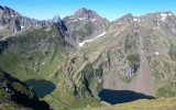
Départ jusqu'au Sanctus
Enlarge - Photo(s) (1)
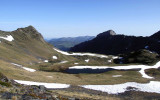
Du Lavedan à Arre Sourins
Enlarge - Photo(s) (1)
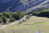
Les Crêtes d'Arre Sourins
Save as favorites
Remove from favorites
Pics
Pics
 Departure/Arrival
 Point of interest


©d.fasoli")